


4KS WALZ AIRPORT, Kiowa, KS
- skylarkcolo
- Oct 26, 2024
- 13 min read
Updated: 7 days ago
Public USE
4KS WALZ AIRPORT, KIOWA, KS
Home of the Cessna Skymasters
FAA INFORMATION EFFECTIVE OCTOBER 2025,
Owner inspection 4KS Airport, 4/2/26 see notes below
FAA Data 4KS file:///C:/Users/16208/Downloads/4KS.pdf
4KS is also a STEM program airport
Location
4KS WALZ Public Airport 4 miles NW of Kiowa, KS.
A no Fee Public Airport


Last Inspection by owner, the grass isgreen and has about 2" of good sod base for spring 2026, overall in good condition, turf grass (Dry), sod, no surface treatment, some gopher activity. The grass is greening up this spring.
Feed gain spring oats crop on both sides of runway, and a stack of round feed hay bails that are six foot high near the south side of runway 21 threshold . Please land safety and have fun.
FAA DATA FOR 4KS WALZ PUBLIC AIRPORT, with the long maintained displace thresholds on both runways, making 4KS around 2900 foot usable with displacements.
DAY TO DARK Operations, Operational emergency night lights are non-standard strobes on at dusk to dawn. One windsock on oil tanks north of home site one new 8/1/2025, also the windsock on the silo is now shredded. New temporary windsock south end of field, near the 03 touchdown point. Tie down chains are in good condition, on the cement pad just north of the main hanger, welcome to use at anytime. LEFT traffic pattern, and watch out for 195ft tower FCC Tower number #1216715, numerous 50 to 100 ft wood poles, oil wells, grain silo/towers, and home site just east of the field.
NOTICE:
Mid 2025 Some military and DoD- ISR contractors are using 4KS for special training, along with manufacturers doing short field testing, and training by the USAF for SkyRaider 2 OA-1K, T-6B Texan II aircraft, and Cessna Super 208B Grand Caravan EX and other flight training on grass short field.
The K0UO RSI Corp antenna test range site, employs the 4KS Walz airport, and its vicinity as a practical learning environment for STEM antenna projects, providing an outdoor real-world setting. If your group has a University aerospace or antenna research STEM program, please let me know.
The site is an accredited wireless outdoor testing range laboratory site, using drones at the on site "4KS" airport. UAS Infrastructure ground-based radar systems, Automatic Dependent Surveillance-Broadcast (ADS-B), with a network of ADS-B receivers to promote safe operations in the airspace.


The K0UO RSI Corp antenna outdoor test range site, is also parallel to the 4KS Walz airport making the test range over 2500 feet for one of the far field ranges, using a portable tower and drones loaded with standardized calibrated RF, EME, and field strength survey instruments (used for DOD, Ham, Commercial wireless telecommunication antennas, AI Data Centers and MOC). The K0UO is a highly technical facility used to precisely measure an antenna's performance characteristics, such as its radiation pattern and gain.
K0UO has significant real estate or so anechoic chambers are not needed.
UAS Infrastructure with ground-based radar systems, Automatic Dependent Surveillance-Broadcast (ADS-B).
The K0UO and RSI Corp. - Radiofrequency Safety International antenna test range site makes use of the 4KS Walz airport near Kiowa, KS and its surrounding area as a practical learning environment for STEM (Scientific, Technical, Engineering, & Mathematics) antenna projects in a real-world outdoor setting. If your group has a School or University aerospace or antenna research STEM program, please let us know. We are using AI, which is now becoming an advanced tool in analyzing, developing, and expanding research in Environmental, RF, and antennas. Efficiency, Flexibility, Reliability at K0UO
Antenna University

NOTE: Vance AFB 1D MOA DAF Proposed Action has been approved is to obtain new airspace that affords the 71 FTW autonomous scheduling and ensures nearby access to airspace necessary to perform low-altitude non-hazardous flight training from 500 feet above ground level (AGL) up to 7,999 feet above mean sea level (MSL), and allows for continuous flight training to 24,000 feet MSL or scheduled independently (500 feet AGL to 7,999 feet MSL), as needed, to support new multidirectional tactical flying training requirements.
The new airspace would be designated as the Vance AFB 1E Low MOA.
The DoD has asked the FAA to establish a new low-altitude Military Operations Area (MOA) under portions of the existing Vance Air Force Base 1A, 1C, and 1D MOAs. The new airspace would be designated as the Vance 1E Low MOA.
ALSO Note, flight are not sunrise to sunset any longer as in 1D MOA, The low-altitude training operations would be performed in the proposed airspace between 8:00 a.m. and 9:00 p.m. Monday through Friday and 2:00 p.m. and 6:00 p.m. on Sundays, local time.
Walz 4KS would have a 3 NM MOA exclusion zone around them in compliance with FAA Order 7400.2 Section 25-1-4. As a result, potential impacts on local 4KS airport VHF/IFR operators would not be significant.
Contact FSS withing 100 miles to obtain real time information, Prior to entering the MOA
For Additional Information: 71 FTW Public Affairs at 71ftw.pa@us.af.mil or 580-213-5250
SEE THE BOTTOM OF THIS PAGE FOR MORE


The K0UO RSI Corp RF test range site can provide test aircraft fitted with an electro-optical, infrared EO/ISR sensor, operator mission, tactical radios, and data link a testing area.
USAF recapitalization of the T-38C Talon flight training program at Vance Air Force Base (AFB) with the new T-7A Red Hawk aircraft. A Draft EIS, dated August 2025, has been provided for public comment.

The proposed action encompasses Vance AFB, located in Enid, Garfield County, Oklahoma, and extends to associated Special Use Airspace (SUA) spanning north-central Oklahoma, northern Texas, and south-central Kansas.
The service says Vance AFB was selected for its unique runway structure and SUA, which are well-suited to support high-volume pilot training, and for its capacity to minimize disruptions to pilot production during the transition phase.
The core elements of the proposed recapitalization include the direct replacement of all 63 T-38C aircraft currently assigned to Vance AFB with T-7A aircraft. This transition will also entail a shift in flight operations at Vance AFB and its associated SUA from the T-38C to the T-7A. The operational shift will necessitate temporary changes to personnel numbers and their dependents in the Vance AFB region, alongside significant construction and upgrade projects for operations, support, and maintenance facilities. Alternative 1 (Anticipated Training Needs): This alternative projects Vance AFB receiving up to 68 T-7A aircraft, maintaining pilot training continuity while phasing out the T-38C fleet. Annual T-7A operations would total approximately 69,800, an increase of about 5,100 operations compared to current T-38C levels due to an additional five aircraft assigned to the installation. This includes approximately 698 annual nighttime T-7A operations.
Alternative 2 (Increased Operational Tempo): Under this scenario, Vance AFB would also receive up to 68 T-7A aircraft, but operations would increase by approximately 25 percent compared to Alternative 1.
Alternative 3 (Future Capacity Needs): This alternative explores future capacity, with Vance AFB receiving up to 99 T-7A aircraft. Operations would be approximately 45 percent greater than Alternative 1, leading to an estimated 101,600 annual T-7A operations and up to 1,016 annual nighttime T-7A operations.

FAA Identifier: | 4KS |
Lat/Long: | 37-02-42.5900N 098-34-12.6500W 37-02.709833N 098-34.210833W 37.0451639,-98.5701806 (estimated) |
Elevation: | 1387 ft. / 423 m (estimated) |
From city: | 4 miles NW of KIOWA, KS |
Time zone: | UTC -5 (UTC -6 during Standard Time) |
Zip code: | 67057 |
Airport Operations
Airport use: | Open to the public |
Activation date: | 11/2012 |
Control tower: | no |
ARTCC: | KANSAS CITY CENTER |
FSS: | WICHITA FLIGHT SERVICE STATION |
NOTAMs facility: | ICT (NOTAM-D service available) |
Attendance: | CONTINUOUS |
Wind indicator: | yes, WINDCONE ON SILO MIDFIELD APRX 110 FT EAST OF RWY CNTRLN. AND ON OIL TANK 400' EAST OF FIELD |
Segmented circle: | no |
Lights: | SS-SR |
Beacon: | white (unlighted land airport) Operates sunset to sunrise. |
Landing fee: | yes, FEE FOR AG OPERATORS |
Airport Communications
CTAF/UNICOM: | 122.8 |
WX AWOS-2 at K51 (13 nm N): | 119.625 (620-886-3290) |
WX AWOS-3PT at AVK (17 nm S): | 121.125 (580-327-6778) |
Airport Services
Fuel available: | C |
Airframe service: | NONE |
Powerplant service: | NONE |
Bottled oxygen: | NONE |
Bulk oxygen: | NONE |

Runway Information
Runway 3/21
37-02.535667N | 37-02.884000N | ||
Longitude: | 098-34.352833W | 098-34.068833W | |
Elevation: | 1367.0 ft. | 1387.0 ft. | |
Traffic pattern: | left | left | |
Displaced threshold: | 225 ft. | 175 ft. | |
Markings: | none | none | |
Obstructions: | 45 ft. trees, 150 ft. from runway, 75 ft. right of centerline, 3:1 slope to clear RY 03 APCH SLOPE 10:1 DUE TO 45 FT TREES 450 FT FM THE DSPLCD THLD. | 5 ft. fence CONTROLLING OBSTN EXCEEDS A 45 DEG SLP. |
Airport Ownership and Management from official FAA records
Ownership: | Privately-owned |
Owner: | STEVEN E. WALZ 17535 SE U.S. HWY 281, MILE 7 KIOWA, KS 67070 Phone (620) 825-6221 |
Manager: | STEVEN E. WALZ 17535 SE U.S. HWY 281, MILE 7 KIOWA, KS 67070 Phone (620) 825-4643 |

Additional Remarks
The taxi way to the concrete tie down area, is on the northern mid part of the field and to the east, and it is clearly marked with orange cones. Park any where not blocking the taxi.
Also feel free to also tied down anywhere along that taxiway, but please allow access for other traffic.
Be aware of highway vehicles on the approach end of R21
Public access is off of U.S. 281 Highway by the airport sign, 300 foot north of the homestead.
For Ag and other operators please contact the owner, water and a large hard surface all weather pad area is available, with improved road and highway access.
"God is always the copilot, open hearts, open minds, open doors for anyone to join in the flying fun"
The owner lives on the field and can be contacted on Unicom 122.80 or by cellular phone 620-825-6221. Emergency fuel may be available, (not for sale),100 LL, auto fuel, and jet.
- | 195 FT TWR NEAR MIDFIELD APRX 375 FT EAST OF RY CNTRLN. |
- | 19 FT OIL WELL PUMP NEAR MIDFIELD APRX 375 FT EAST OF RY CNTRLN. |
- | WIND SOCK ON 38 FT SILO 375 FT LEFT AT MID FIELD RY 23. |
- | NSTD DSPLCD THLD MARKINGS (TFC CONES). |
- | RWY 3/21 TURF UNEVEN DUE TO GOPHER HOLES |
- | BIRD AND WILDLIFE ACT NEAR ARPT |
- | 17:1 APCH SLOPE TO LIGHTED OIL TANK 550' FROM DSPLCD THLD R/W 21 |
- | FOR CD CTC KANSAS CITY ARTCC AT 913-254-8508. |
- | NUMEROUS OBST, POLES, OIL WELL AND BLDG EAST OF FIELD |


Also the 50 to 195 foot poles and radio towers east of the runway

Instrument Procedures
There are no published instrument procedures at 4KS.
Some nearby airports with instrument procedures:
KAVK - Alva Regional Airport (17 nm S)
KANY - Anthony Municipal Airport (24 nm E)
8K2 - Harper Municipal Airport (29 nm NE)
3K8 - Comanche County Airport (38 nm W)
KPTT - Pratt Regional Airport (40 nm N)


htts://wireless2.fcc.gov/UlsApp/AsrSearch/asrRegistration.jsp?regKey=2614222


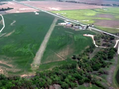
Above: Looking SW R21,

Above: 4KS Hanger


THE NEW 1E MOA 5,719 aircraft transited the proposed Vance 1E Low MOA from August 2023 through July 2024 (38 percent civilian operators [37 percent by general aviation], 14 percent military, and 48 percent unknown VFR operators). Overall, there was an average of 16 crossings per day (6 IFR and 10 VFR) in the airspace. Further, the busiest traffic periods occurred between 10:00 a.m. and 4:00 p.m., with an average of 1 to 2 aircraft crossings per hour. NEW 1E would add 1,170 flight operations per year in the airspace within the proposed Vance 1E Low MOA, an increase of just over 20 percent. T-38C sorties would include one to four aircraft in the proposed Low MOA at a time. Should Alternative 1 be selected for implementation, pilots approved to operate in the proposed MOA would be responsible for remaining within the assigned area. The supporting controlling agency, per letter of agreement determination, may assist with providing radar advisory service, workload permitting, to aid pilots in remaining in the assigned areas.

As established by FAA letter of agreement with Vance AFB and the 71 FTW, Vance ATC and FAA control centers would procedurally deconflict IFR traffic by restricting military operations by sector or by altitude band, as needed to route crossing air traffic through the remaining airspace.

yielded the operations listed in Tables 3.3-2 through 3.3-9. More than 5,700 aircraft crossed or
operated within the proposed Vance 1E Low MOA between July 2023 and August 2024 (Table
3.3-2). Of the air traffic crossings by operator type listed in Table 3.3-2, 37 percent of the total
crossings were civilian, general aviation operators, 14 percent were military operators, less than 1 percent were civilian air carrier and air taxi operators, and 48 percent were unknown aircraft operators (for which aircraft type and flight plan could not be associated with tracking data).
This would be the most efficient approach to deconflict IFR crossings from military operations in the proposed Vance 1E Low MOA. A less efficient alternative would be to reroute the IFR traffic, to the north or south, around the proposed Vance 1E Low MOA which could result in substantial delays for some flights. VFR traffic in the proposed Vance 1E Low MOA. WALZ 4KS would have a 3 NM MOA exclusion zone
around them in compliance with FAA Order 7400.2 Section 25-1-4. As a result, potential impacts on local airport IFR operators would not be significant.

Col CHARLES D. THROCKMORTON, Department of the Air Force (DAF)
71st Flying Training Wing (71 FTW) at Vance Air Force Base (AFB), Oklahoma to support Fighter Bomber Fundamentals (FBF) pilot training syllabus requirements. The proposed airspace would be managed and scheduled by the 71FTW.
For Additional Information: 71 FTW Public Affairs at 71ftw.pa@us.af.mil or 580-213-5250

Note, ADS-B Out is not required for a civilian aircraft flying VFR inside the proposed Vance 1E Low MOA (or the existing higher Vance MOAs).
Why Not?
The Vance 1E Low MOA is non-regulatory special use airspace (a Military Operations Area), not controlled airspace (Class A, B, C, or the specific Class E that triggers ADS-B). Per 14 CFR §91.225, ADS-B Out is only mandatory in these areas:
Class A, B, or C airspace
Within 30 NM of a designated Class B primary airport (the “Mode C veil”)
Class E airspace at or above 10,000 feet MSL (excluding the airspace at and below 2,500 feet AGL)
Certain Class E over the Gulf of Mexico
Above the ceiling and within the lateral boundaries of Class B or C up to 10,000 feet MSL
The Vance 1E Low MOA sits at 500 ft AGL to 7,999 ft MSL in rural northwest Oklahoma (Alfalfa/Woods counties) and south-central Kansas (Barber/Harper counties). This area is mostly Class G (below ~1,200 ft AGL) or Class E (above that but well below 10,000 ft MSL). It is nowhere near any Class B Mode C veil:
Oklahoma City Class B is ~70–80+ miles south.
Wichita Class B is ~90–100+ miles east.
No part of the MOA triggers the ADS-B rule. The same applies to the overlying Vance 1A/1C/1D MOAs.
Important Notes
Even when the MOA is active (still pending FAA final designation as of Feb 24, 2026 — no chart depiction or NOTAMs yet), it does not add any ADS-B requirement. VFR flight is allowed at all times (with extreme caution during published activation hours).
You still need to comply with see-and-avoid (FAR 91.113) and monitor the appropriate frequency (usually Kansas City Center or Vance Approach when they’re working the MOA).
Strong safety recommendation: Even though it’s not required, having ADS-B Out (and In) is highly advisable here. T-38C Talons (and future T-7As) will be doing high-speed, low-level tactical work. Many military jets broadcast ADS-B, so you’ll get traffic alerts on your screen. The MOA is busy during training windows (Mon–Fri 0800–2100 local, Sun 1400–1800).
Transponder (Mode C) is also not required in this low, non-veil area unless you’re above 10,000 ft MSL or in other mandated airspace.
Bottom line: Fly VFR through Vance 1E Low MOA without ADS-B and you’re legal — but treat it like busy military training airspace and use every tool you have (eyes outside, radio, and preferably ADS-B) to stay safe.
The airport is at The KØUO Rhombic Antenna Farm and Test Range: Home to the World's Largest amateur radio (ham), High Frequency (HF) Wire Antennas. Known as "Antenna University"
4KS is also a STEM program airport
We support the Amateur Radio Digital Communications (ARDC) and their STEM programs.
KDOT, you will find an aviation education trifold flyer. Starting November 2025, your local school districts can apply for high school aviation education courses that are outlined in the flyer. We have a video posted on our YouTube channel discussing these courses, that you can access here.
If your school is interested in adopting an aviation education program, please feel free to either have them reach out to us or schedule a meeting and include us. With our academic partners, we can answer any questions and walk your school district through the process. We can also put them in touch with other school districts that currently have an aviation education program.


KDOT: These courses can be adopted anywhere, regardless of how rural or resource constrained your school district may be. There are strategies that can overcome many obstacles. Please help us spread the word.
Ray Seif | Director of Aviation
O: 785-296-6336
M: 785-496-8630
Kansas Department of Transportation
Eisenhower State Office Building
700 SW Harrison St, 9th Floor
Topeka, KS 66603-3745


RSI Corp at the 4KS airport is a Environment, Health and Safety Firm, a comprehensive discipline and framework of regulations and best practices for protecting people and the planet by minimizing workplace hazards, preventing injuries and illnesses, ensuring environmental compliance, and managing risks like pollution and waste. It involves creating a safe workplace, adhering to laws from agencies like OSHA and EPA, training employees, and fostering a strong safety culture, for Hyperscale AI data centers and MOC. Since the 1990s, RSI Corp, located in Barber County, Kiowa, KS, has provided expert Environmental Health and Safety (EH&S) services to some of the largest AI data centers and NOCs. Their clients include Verizon, AT&T, T-Mobile, the Department of Defense, Google, UPS, and FedEx.